Maps of the magical town of Creel and Sierra Tarahumara
The magical town of Creel, located in the impressive landscape of the Sierra Tarahumara and the magnificent Copper Canyon, offers travelers a unique experience full of natural beauty and rich cultural heritage. Exploring this region can be an adventure in itself, and having detailed maps to navigate the area can enhance your trip. In this article, we offer you a special selection of downloadable maps where you can easily find your way in Creel, the Sierra Tarahumara and the Copper Canyon. Maps of the magical town of Creel and Sierra Tarahumara:
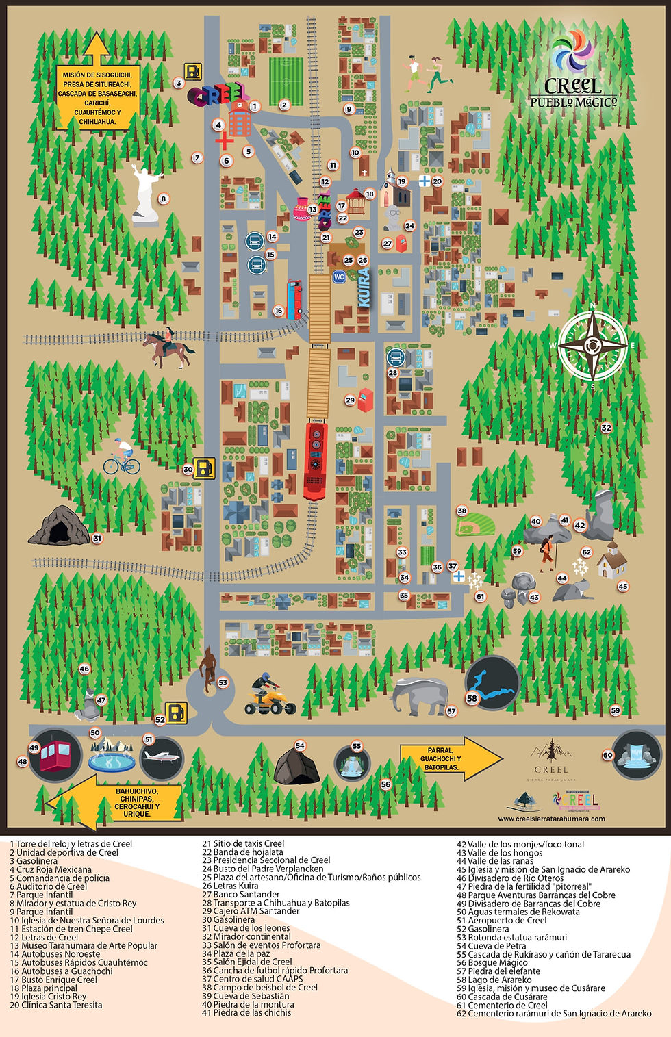
1. Map of the magical town of Creel, Chihuahua and the chepe train.
To begin your exploration of this magical town, it is essential to have a map of Creel. This map will help you locate the main points of interest, such as the historic train station, main squares, Rarámuri craft shops and nearby natural attractions. It will also show you the layout of the magical town, making it easier to plan your itinerary and navigate the streets. Downloading a map of Creel will ensure you don't miss any of the hidden treasures and amenities this town has to offer.
2. Map of the Sierra Tarahumara, its magical towns and the chepe train.
Exploring beyond Creel, the Sierra Tarahumara is a vast and impressive mountain region that covers a significant part of northwestern Mexico. Renowned for its rugged beauty, deep ravines, and indigenous Rarámuri communities, a map of the Sierra Tarahumara will help you explore this fascinating area. The map will indicate the main road routes, towns, waterfalls and tourist attractions as well as the magical towns of the area such as Guachochi, Batopilas and Parral, allowing you to immerse yourself in the natural wonders and cultural heritage of the region.
3. Map of the Copper Canyon (coming soon)
The Copper Canyons, also known as Copper Canyons, are a series of deep ravines spanning more than 25,000 square miles in the Tarahumara Mountains. This stunning natural wonder is larger and deeper than the Grand Canyon, making it a stunning destination for outdoor enthusiasts and nature lovers. Downloading a map of the Copper Canyon will help you locate the different ravines, such as Urique, Batopilas and Sinforosa. You will also be able to identify the different panoramic viewpoints, hiking trails and attractions within the ravines, allowing you to plan your adventures with ease.
4. Hiking Trails Map (coming soon)
For those looking for an active exploration of the Sierra Tarahumara and Copper Canyon, a map highlighting hiking trails in the area is a must. These trails will guide you through the rugged landscape, crystal-clear rivers and picturesque waterfalls, giving you an unforgettable outdoor experience. The hiking trail map will also indicate each trail's difficulty level, duration, and any additional attractions along the way. With this map in hand, you can embark on memorable hiking adventures, connecting with nature and immersed in the beauty of the region.
5. Cultural Map (coming soon)
The cultural map of Creel, the Sierra Tarahumara and the Copper Canyon will help you delve into the rich heritage of the Rarámuri people and their traditional way of life. This map will indicate the locations of significant cultural sites such as ancient cave paintings, indigenous villages and sacred places. By following this map, you will be able to gain a deeper understanding of the unique culture of the Rarámuri and create meaningful connections with local communities during your journey.
In Summary
Exploring the magical town of Creel, the Sierra Tarahumara and the Copper Canyon is a truly remarkable experience. With the availability of downloadable maps, you will be able to plan your trip meticulously, ensuring you make the most of your time exploring this captivating region. Whether you're interested in hiking, immersing yourself in the local culture, or simply enjoying the stunning landscapes, having these maps at your disposal will enhance your adventure and help you create memories that will last a lifetime.


